Close to my old home in Plymouth is Blockhouse Park. I was familiar with the layout of the old fortification visible today, but had no idea of what they represented until a recent visit, when I saw these new, to me anyway, information boards.
Described as a small artillery emplacement built in 1780 (1779 on internet) as an outer defence for Devonport Dockyard, modified in 1811 and obsolete by 1840.
The outer works, now an earthen ditch and bank, originally revetted in stone.
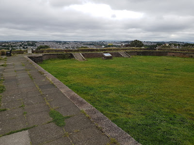
The view from the outer ramparts looking northwest towards the dockyard. The fortification lies on the highest point within the city and dominates the ancient route into the city from the north, the only route not protected by deeply incised valleys floored by tidal estuaries prior to the start of the 20th Century.
The interior of the outer works. The old earthworks were improved with brick in the 1930s in preparation for use as an anti-aircraft, searchlight and Barrage balloon site in WW2.
The western rampart.
Looking across the interior of the fort to the north, the topography is markedly less incised than the deep valleys to northwest and southeast.
Information board within the fort, showing the likely blockhouse construction within. Probably a stone built blockhouse at ground level, with a wooden first floor. Contemporary with similar structures built throughout North America during the French-Indian (7 Years War) and Revolutionary (American War of Independence) Wars.
Another information board showing a reconstruction of the whole site as originally built.
This was an unexpected plus, resulting from us looking for a good site to view a firework display. As a family, we knew about the use of the site in WW2 and that it had an older history, but no idea of the 18th Cent origins and the contemporary nature of the defences with those built in North America.
Thanks for looking.


Interesting find
ReplyDeleteThanks Will
Delete